Why is my update stuck at X%?
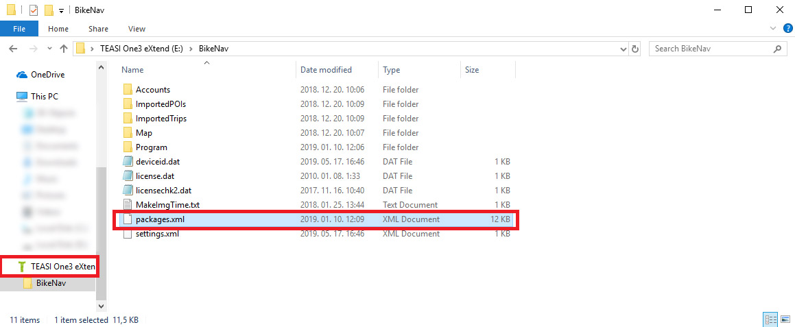
To resolve this issue, please, make sure that the Teasi is properly connected to the computer (tap the “Connect to PC” option on the Teasi once the USB cable is plugged in to the device). Then, access the Teasi’s file system: Open the File Explorer on your computer, and look for the Teasi, which you will find among the other drives (C:, D:, etc. – the Teasi will have its own logo and device name). Then, open it, and delete the /Bikenav/Packages.xml file. Afterwards, unplug and restart the Teasi device. Finally, re-connect it to the Tool with the USB cable, and you will be asked to update again.
Why aren't my maps installed correctly?
If you are seeing this error message, it might not prevent you from having a fully functional software. However, it is recommend to update the device. To do so, please, make sure that the Teasi is properly connected to the computer (tap the “Connect to PC” on the Teasi once the cable is plugged in). Then, access the Teasi’s file system: Open the Windows File Explorer, and look for the Teasi, which you will find among the other drives (C:, D:, etc.). Then, open it, and delete the /Bikenav/Packages.xml file. Afterwards, unplug and restart the Teasi device. Finally, re-connect it to the Tool, and you will be asked to update again.
Why is the route planning not possible?
Please, note that the Tahuna Tool is a recreational software, which is not designed to navigate cyclists through thousands of kilometers. Therefore, you can only plan routes up to 300 km in beeline length, which might still cover 400-500 km on the roads. However, if you would like to exceed this limit, we recommend you to compile routes by building up multiple segments near one another. To create segments, simply click the map screen on different spots to connect them in Tour Creator.
If this issue occurs on a Teasi device, the reasons could be more diverse. Besides the route length, the issue could also be that the country maps are not downloaded which you are trying to plan the route through. Furthermore, you should also try zooming in the map, and planning the route along the path of the roads, because some locations might not be approachable by bike.
Why is the same update offered multiple times?
If you are experiencing this phenomenon, the update might not have been run successfully. To resolve this issue, please, make sure that the Teasi is properly connected to the computer (tap “Connect to PC” on the Teasi once the cable is plugged in). Then, access the Teasi’s file system: Open the Windows File Explorer, and look for the Teasi, which you will find among the other drives (C:, D:, etc.). Then, open it, and delete the /Bikenav/Packages.xml file. Afterwards, unplug and restart the Teasi device. Finally, re-connect it to the Tool, and you will be asked to update again.
Why am I constantly being asked to download a country?
This phenomenon occurs because maps need to be downloaded for both the Teasi device and the Tahuna Tool separately. When the Teasi is connected, the Tool only displays the maps downloaded for the Teasi device. After disconnection, only those maps appear which are downloaded for the Tahuna Tool. Therefore, it might seem that you are asked to download a map multiple times, but in fact, it is downloaded to different storages.
However, if it seems to be a recurring problem, please, connect the Teasi to the computer (tap the “Connect to PC” option on the Teasi once the USB cable is plugged in to the device). Then, access the Teasi’s file system: Open the File Explorer on your computer, and look for the Teasi, which you will find among the other drives (C:, D:, etc. – the Teasi will have its own logo and device name). Then, open it, and delete the /Bikenav/Packages.xml file. Afterwards, unplug and restart the Teasi device. Finally, re-connect it to the Tool with the USB cable, and you will be asked to update.
How to name a track in the Tour Creator when saving it?
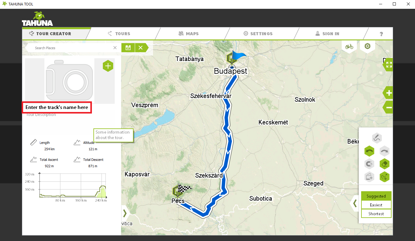
Before saving a route in Tahuna Tool, you need to give it a name first. To do so, click the “Tour Title” part under the track image in the tour details panel (left side of the window – see in the screenshot below). After you typed in the desired name, click the “Save” button in the top, and select the destination folder where you wish to save the track.
Why do my maps disappear upon disconnecting the Teasi from the Tool?
The reason is that maps need to be downloaded for both the Teasi device and the Tahuna Tool separately. When the Teasi is connected, the Tool only displays the maps downloaded for the Teasi device. After disconnection, only those maps appear which are downloaded for the Tahuna Tool. Therefore, it might seem that you are asked to download a map multiple times, but in fact, it is downloaded to different storages.
How to restart the Teasi if it's completely stuck?
If the device is completely frozen and doesn’t respond to any commands, please, press and hold the Power button for at least 30 seconds. It is going to reboot the device.
What to do if a plus “+” sign appears on the Teasi, and I cannot proceed?
This is the screen calibration, which is needed after ROM updates. Please, tap the “+” sign as many times as the device requires it on different spots on the screen. Note! We recommend you to use a pointed object for this process (like a pen), because the screen calibration needs to be very precise, otherwise, it won’t disappear.
If the issue still keeps occurring after following the mentioned method, please, contact info@tahuna.com
Why is there no route planned after I click the "GO" button in Tahuna Tool?
The reason is that the first address search only marks the starting position, since the Tool doesn’t recognise the current location of your computer automatically. Therefore, you need to search for two locations for planning a route: the first search is going to mark the starting point, the second one is the destination spot. Both need to be confirmed by clicking the “GO” button.


